
For That's My World let me take you up to northern Israel, to the remains of a city that flourished from Hellenistic times until the earthquake of 749 CE.
At first it was a pagan city, like the other nine cities of the Decapolis.
In Byzantine times it turned into a center of Christianity.
.
 This hill looked to the ancients like a mare's head and neck, so when they built a city on top of it in the 2nd century BCE, they named it Hippos or in Aramaic, Susita.
.
 Our group of archaeology volunteers was given a guided field trip up there last Thursday.
.
We were careful to stay on the path on the one narrow ridge that leads up to Susita National Park. Up until the 1967 Six Day War, when Israel won the Golan Heights, this was where Syrian territory began.
Till today the old Syrian minefield is there.
.
.
 It was thrilling to walk on the 2,000 year old road. I had to fight back tears. I was humming "The Appian Way" movement from Respighi's "The Pines of Rome."
.
These basalt pavers form the original Decumanus Maximus, the main east-west street.
.
Here the view is to the west. You can see a bit of the Sea of Galilee down below.
.
 And the view to the east, to the Golan plateau.
.
 Enlarge the photo to better appreciate the carvings in the local basalt stone.
 Enlarge the photo to better appreciate the carvings in the local basalt stone.
.
 An ancient game etched in stone.
.
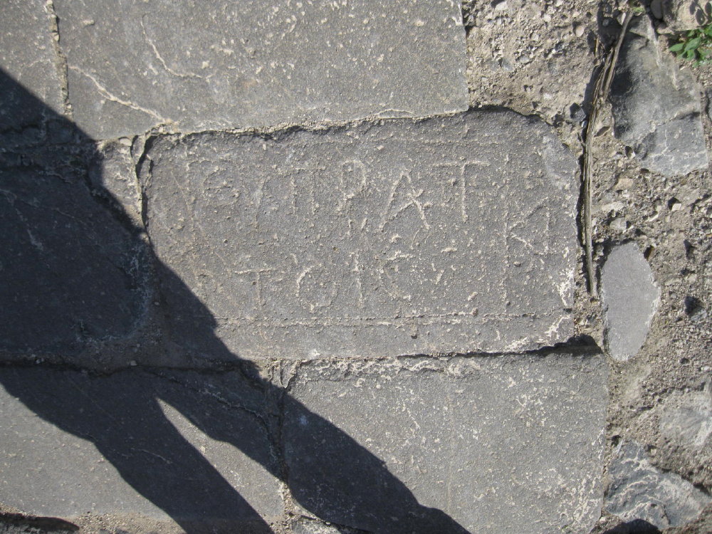
 An inscription inside a tabula ansata.
 An ancient game etched in stone.
.
 An inscription inside a tabula ansata.
.
 Oh! and don't you just love this?!
 The Romans used their engineering skills to bring water UP to the city from springs lower down.
 and then the smaller second opening.
 Oh! and don't you just love this?!
Masons' marks, the "signatures" of the men who cut the stones!
.
 The Romans used their engineering skills to bring water UP to the city from springs lower down.
The water flowed through an aquaduct in the hills and then into these interlocking sections of pipe on the side of the Decumanus.
.
.
Note the size of the first opening . . .
.
.
 and then the smaller second opening.
Going from large into small channel increases the pressure of the running water and makes it go higher up.
I should have checked with my engineer daughter first, but apparently this is now called Bernoulli's principle. I think the Roman's didn't have a name for it; they just DID it!
.
Come back during the week to see the churches of Susita. Shalom!
Love the first picture! Looks like a very nice and peacefull place. I`v not been in north of Israel, so thats must be next time:-)
ReplyDeleteWish you a good week!
Truly beautiful! I envy you to be able to travel in places like that. Thanks for sharing.
ReplyDeleteThis is so amazing! It just boggles your mind to see the ancient engineering skills and what they were able to accomplish. Terrific photos, Dina!
ReplyDeleteImagine all the people who have walked on that road in the last 2,000 years.
ReplyDeleteAn Arkies Musings
"The Pines of Rome" is certainly appropriate accompaniment to this, Dina! Great post! We look forward to more!
ReplyDeleteI loved coming on this walk with you, mines and all. It was like time travel, despite the fact I tread Roman basolato nearly every day!
ReplyDeleteThank you for explaining so beautifully these gorgeous places and for illuminating us on Roman engineering. The photos reveal your passionate eye.
Ciao Dina and again thanks,
Eleonora
thank you very much for your kind words. i really appreciated.
ReplyDeleteThis is an awesome post, Dina! You always show us the most interesting things! The detailed carvings in the stone are wonderful.
ReplyDeleteI'm a bit overloaded with Roman relics but I am still glad to see these beautifully carved stones.
ReplyDeleteWhat an awesome historical place to visit, great photos. And thank you for the tour.
ReplyDeleteAwesome place! Never been there, but it reminds me a lot of Beit She'an.
ReplyDeleteThe road looks in better shape than in those we can see in Rome or in Ostia Antica! Their state is amazing after all these centuries.
ReplyDeleteI'm having a tough time visiting blogs recently, between monitoring election results and my cousin from Chicago visiting, so I've only caught up with your new archeology posts now.
ReplyDeleteWhen you mentioned that the paved road was 2000 years old, my hair stood on end again. And the aqueduct is just absolutely amazing!
Fascinating. Such layers of history.
ReplyDeleteBeautiful images.
ReplyDeleteA magnificent trip through time, Dina. I would have had tears in my eyes, too.
ReplyDeleteAll these details are just fantastic!
ReplyDeleteI sometimes go back and forth with your blog. I didn't read this entry yesterday. Now I'm excited. This is the Golan Heights. Minefields and politics keep development at bay. If I ever get to Israel this will be part of the journey. Love the details in the path. journeymen marks Fabulous!
ReplyDelete