Showing posts with label maps. Show all posts

Tuesday, March 10, 2015

Israel National Trail

.

A blaze of  blazes in the forest!
The orange-blue-white  blazes mark the Israel National Trail.
The blue and white is for a local trail.


Here's another marker on a rock, overlooking my neighborhood in the town of Meitar.


In the opposite direction are the South Hebron Hills in the West Bank.


Over to the west lies the Mediterranean and the Gaza Strip.

The 620-mile,  1000-km Israel Trail is celebrating 20 years since its inauguration in 1995.
I'm lucky to have it right down in Meitar's backyard.
.
All photos can be enlarged with two clicks.
Linking to ABC Wednesday.
.

Sunday, September 7, 2014

Orthophoto of Meitar

.

Shalom, welcome to Meitar, my new hometown in the Northern Negev!
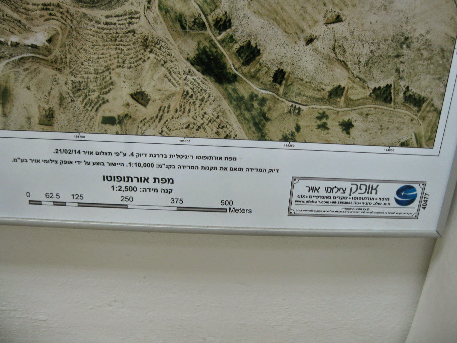
I discovered this February 2014 photo on the wall of the Meitar Local Council moked.
Click a few times to enlarge it. 

The planned community (yeshuv kehilati) was  begun in 1984.
Neighborhoods were added gradually and the 5th (or 6th?) one is currently under construction.
The schools, stores, sports center, and public buildings are in the middle (for me, a 14-minute walk from home).

On our west is Kibbutz Kramim with its big solar field.
To the north is Meitar Forest and the Israel Trail.
The road on top of the photo goes along the border with the West Bank.
The green on the bottom is the edge of the big Bedouin town Hura. 


Ofek Aerial Photo produced this 1:2,500 orthophoto map.

Wikipedia explains

An orthophoto . . .  is an aerial photograph geometrically corrected ("orthorectified") such that the scale is uniform: the photo has the same lack of distortion as a map. Unlike an uncorrected aerial photograph, an orthophotograph can be used to measure true distances, because it is an accurate representation of the Earth's surface, having been adjusted for topographic relief, lens distortion, and camera tilt.
You can enjoy Ofek's panoramic aerial photos of Israel at their gallery
 .

Sunday, April 6, 2014

Learning the land on foot

.

MEITAR MARCH
    Starting point


Bright and early Friday morning hundreds of Meitar pupils set out on the 23rd annual Meitar hike.


Granddaughter Libby's pre-kindergarten class sat down for breakfast, and their teacher, Orli, used the time to teach them how to look for animal footprints and droppings and try to guess which animals had been there not long before them.


A general orientation of what's out there.
Meitar at the bottom.
Straight west on the middle line would be Lakiya [Bedouin town],  then somewhere on a bare hill the Negev Brigade [Palmach] Memorial.

Going from 10:00 to 2:00 on the "map"--
Hura [Bedouin township],    the Bedouin diaspora [i.e. unrecognized settlements],   Omer [Jewish town],  Beer Sheva [big city]
and to the right:  Sansana Forest,   the Green Line,   Sansana [a Jewish settlement just over the Green Line in the West Bank],    Ramabin Tribe [or clan].

See the area on a real Google map here.


 Border Police were stationed along the route, making sure the kids did not take a wrong turn.

 
I was surprised to come upon antiquities, only partly excavated a long time ago, it looked like!
Will have to find out more about that. 


The whole hike in the desert was only two and a half hours, and then we descended down to little Meitar, home.
.
It's great to have the South Hebron Hills / Northern Negev nature right in our backyard.
.

Monday, November 18, 2013

For opportunities, go south

.

Be'er Sheva, population 206,000, is often called The Capital of the Negev, since it is the largest city in the Negev desert of southern Israel.
But this big banner, hung on the side of the theater we saw in yesterday's post, takes it a step further.
The new slogan is BE'ER SHEVA -- ISRAEL'S  CAPITAL OF OPPORTUNITY.

It sounds better in Hebrew:  Be'er Sheva -- Birat hahizdamnuyot shel Yisrael, with "opportunities" being in the plural.
.
UPDATE: I realized from a comment that a map would be useful.
My town, Meitar, is northeast of Beersheva.  It is just south of the Green Line ("1949 Armistice Line"), i.e. south of the West Bank. 

Click on the map a few times to enlarge it.
.
(Linking to Our World Tuesday and Signs, signs.)
.

Tuesday, May 28, 2013

Terra orbitus, T in O maps

.

For ABC Wednesday's T-Day  let's talk about "T in O maps."

I first learned that term at last month's Jerusalem Green Pilgrimage symposium.
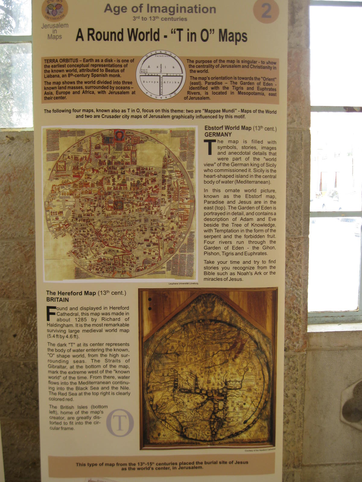
Lecturer Benjie Talor had his Jerusalem in Maps exhibition set up in the passageway and he kindly gave me fascinating facts on each poster.  


The Age of Imagination, 3rd to 13th centuries, saw the earth as a disc.
The terra orbitus, attributed to an 8th century Spanish monk, is one of the earliest conceptual representations of the known world.
Using a T to divide the land masses into Asia, Europe, and Africa, such maps placed Jerusalem in the center.
Their purpose was to emphasize this centrality of Jerusalem and Christianity in the world.
.
Please enlarge the photo (click once, then again) to get a good look at the medieval examples of world maps.


T in O city maps, graphically influenced by the terra orbitus motif,  made Jerusalem a round city.
Click and enjoy these two 13th century Crusader maps.
.
One of the ca. dozen map posters ends with this thought:
Yir'ushalem, the organization which produced this exhibition, has attempted to bring forth both the Heavenly and the Earthly Jerusalem within the viewer's grasp.
We have viewed the city from deep within the spiritual beliefs of pilgrims to the view from the heavens, and its centrality for the major monotheistic religions.
Many have tried to paint Jerusalem's portrait, but no artist or cartographer has painted her like the Master of the Universe. 

Credit:
Concept development--Benjie Tal'or (more about him here and here)
Scientific advisor--Prof. Rehav Rubin (HUJI)
Curator--Yoni Shapira
Graphic designer--Kobi Ariel
Exhibit production--LHS Innovative Projects Ltd.
.

Tuesday, January 8, 2013

Celestial cartography at Hebrew University

.
Shalom from Israel where this week's weather is wet, wild, and windy.
Tune in tomorrow to see if Jerusalem really gets the expected snow!


Meanwhile, for ABC Wednesday,  Z is for zodiac.

But this, that I found on the wall of the National Library of Israel, is more than just a zodiac;  it is a famous example of celestial cartography from 1515.
It is a reproduction of Albrecht Dürer's woodcut called  Imagines coeli Septentrionales cum duodecim imaginibus zodiaci, a star chart of the Northern hemisphere sky with images of the 12 zodiacal constellations.

In the corners are four historical astronomers:  Aratus of Cilician Soli, Ptolemy, Marcus Manilius, and Al-Sufi.

You can click once on the photo and then click again, to see it much enlarged.

Fascinating details about Albertus Durer's star charts are told in Electrum Magazine

What other treasures lie in these big locked drawers of the National Library's Map Room?
Only the librarian knows for sure.
.

Sunday, January 6, 2013

The city of God

.
Psalm 87

1. Of the Korachites. A psalm. 
A song, its foundation on the holy mountains.


2. The LORD loves the gates of Zion, more than all the dwellings of Jacob.
3. Of you glorious things are spoken, O city of God.   Selah.

4. I recall Rahab and Babylon to those who acknowledge Me; behold: Philistia and Tyre, with Nubia―“This one was born there.”


5. But of Zion, it is said, “Every single person was born in it.” He, the Most High, establishes it.
6. The LORD records in the census of peoples: “This one was born there.”   Selah.


7. And they, singing as they dance: “All my roots are in you.”


Translation: Rabbi Benjamin J. Segal.

PHOTOS (all are enlargeable)

1. Zion Gate
2. Heinrich Bünting's map of 1581 with Jerusalem (Zion) as  center of the world.
Please enlarge the photo to appreciate the ceramic map.
More about this work in a previous post.
3-4. Singers/drummers/shofar blowers lead the joyful procession through the Jewish Quarter of the Old City down to the Western Wall where the boy will become a bar mitsvah.
.
This post is for Robert Geiss' weekly PsalmChallenge at daily athens photo.
You are welcome to join in illustrating the Book of Psalms.
.
(Also linking to Whimsical Windows, Delirious Doors meme.)

Saturday, December 8, 2012

God help us

.
Psalm 83 today for the weekly meme PsalmChallenge.
.
1. A song. A psalm. Of Asaph.

2. O God, do not be silent; do not be mute; do not be quiet, O Deity!
3. For Your enemies rage; those who hate You rear their heads.
4. Against Your people they plot craftily, conspire against Your treasured ones.
5. They say, “Come let us wipe them out as a nation; Israel’s name will be remembered no more.”
.

    (photo credit: AP/Hasan Sarbakhshian,
      in The Times of Israel


6. Indeed they have conspired as one, making an alliance against You—  

7. the tents of Edom and the Ishmaelites, Moab and the Hagrites,
8. Gebal and Ammon and Amalek, Philistia with the inhabitants of Tyre.
9. Assyria too joins with them, serving as an arm for the sons of Lot.       Selah.

10. Treat them as You did Midian, with Sisera, with Jabin, at the brook Kishon—
11. they were destroyed at En-dor; they became fertilizing refuse for the ground.
12. Make their nobles like Oreb and Zeeb, all their princes like Zebah and Zalmunna,
13. those who said, “Let us take as our possession the pasturelands of God.”
.
14. O my God, make them like tumbleweed, like chaff before the wind.
15. As a fire burns a forest, and as a flame sets the mountains ablaze,
16. so pursue them with Your tempest, terrify them with Your windstorm.
17. Fill their faces with shame, so that they seek Your name, O LORD.   
18. May they be abashed and terrified forever, may they be disgraced and doomed.
19. May they know that it is You whose name is the LORD, You are exclusively supreme over all the earth.
.
Translation by Rabbi Benjamin J. Segal.  See also his notes
.
A map of  Israel and the surrounding countries: see Atlapedia.
.
Monday, February 7, 2011

Trams in training!

.
 For the first time in 3,000  years,  trams are moving through the streets of Jerusalem!
YAY!!
Yesterday was my first time to see one actually moving. 
I was so excited to see it coming that I ran across the street in order not to be shooting into the sun when  the tram would pass by.
The shadow on the zebra crossing is of the guard who shouted at me "Hurry up, fast!"
.
The trams and their drivers will be doing such training runs for a few months before they dare to load up with curious first-time passengers.

Route map from CityPass 
(can be enlarged with a click) 
.
What you see in the top photo  is the end of the train as it goes along Jaffa Street in the direction of the Old City.
It seemed rather incongruous, a sleek modern light rail in the narrow street  lined with old stone buildings housing mom and pop shops, right next to the old Machane Yehuda vegetable market.
.
But I guess here in Jerusalem contrasts are nothing new to us.
.
Most residents hated the  dug  up streets and congestion, but for me as a blogger it has been fascinating to watch and record, for these  many years, the building of Israel's first light rail transit system.
(Proof  of which is under my label "tram.")
.
I'm proud to say That's My World.
.

Tuesday, October 12, 2010

Madaba mosaic map

.
Photo by Kay of Musings
.
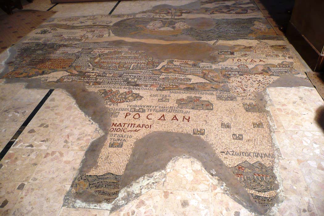
For ABC Wednesday M-Day let's look at the magnificent Madaba mosaic map.

Craftsmen made it from more than two million colored tesserae sometime between the years 542 and 570.
.
The photo above shows the surviving parts of the mosaic, in situ in the church in the Arab village of Medeba in Jordan, where it was rediscovered in 1892.
Kay, my friend in Hawaii, author of the fine blog Musings, was actually there and sent me this picture!
.
This photo shows our reproduction of the Jerusalem section of the map. It hangs near the Cardo in the Old City.


Yes, the same central Cardo that Israeli archaeologists in 1967 searched for and found (and later restored), based on this map! (It's the colonnaded road going across the map, starting at Damascus Gate on the left.)
.
This year archaeologists dug near the Jaffa Gate (at the bottom of the map) and were thrilled but not surprised to find the Decumanus (the Roman road which led up to the Cardo), shown with a sharp right angle here above.
.
And in 2006 my trowel was one of the lucky ones to first scrape through to the big beautiful paving stones of the Secondary Cardo (visible at the top of the map, its row of columns showing).
.


The Madaba mosaic is also a devotional map, so the most important church, the Holy Sepulchre, and also the Nea Church are distorted out of proportion to the rest of the city in order to show their conceptual importance for the Christians.


And naturally, the Byzantine Jerusalem depicted has the East on top.


Being the oldest surviving original cartographic depiction of the Holy Land, the Madaba map is famous and beloved in our country and you find it on postcards, ceramics, and all kinds of souvenirs.


But a few days ago I had to laugh to find it on a kneeling cushion in St. George's Anglican Cathedral in east Jerusalem!
.
I could go on and on about the fascinating history and value of this map.


But I recommend you play around with your mouse on this great 3D map with overlays.
.
And you can see the Greek Orthodox church in Jordan where the mosaic resides at BiblePlaces.com.
The Franciscans have a virtual tour of the Madaba map, based on the book by Piccirillo.
.

Have fun!
.

Saturday, January 16, 2010

The bus to another world

.
Our Egged bus driver had lots of mirrors--good for the "Weekend Reflections" meme over at James' blog.
The drive from Jerusalem down to Ein Gedi is just over an hour.
As a senior citizen I pay half-fare for public transportation, so my round trip fare was only 36 shekels.
With my discount the Nature Reserve entrance was NIS 13.
So we had a full day hiking in the desert for only 49 shekels (about $13 or 9 Euros).

Just east of Jerusalem the desert begins, and also the West Bank.
Quite soon you come to a T in the road: left to Ramallah (the seat of the Palestinian Authority government) or right to Qumran, Ein Gedi, Masada, Ein Bokek, and Neve Zohar.
.
At the checkpost the back of one van was being searched. Our bus driver was getting worried about the schedule he has to keep, so he started beeping, gesturing, and shouting out the window for the guards to pull the car over to the side of the road and let us through.
.
What you see next to the left side of the road is already the Dead Sea.
.
While searching (unsuccessfully) for a good modern map to illustrate this, I came across a fine website with a map of FIRST CENTURY Israel! All the place names from the Bible, and Ein Gedi figures prominently. Check it out!
.

Thursday, August 20, 2009

Heading home at sunset

.
click for bigger photos

I had a good visit near the coast yesterday, mostly looking out from a relative's balcony at this view--construction of a new wing of Tel Aviv Museum.

The strange tower on the left soars upward out of a 17-floor office building in HaKirya military base.

The bus home to Jerusalem passes the Azrieli towers.
The third, triangular highrise is behind these two.

Just a few minutes on the highway out of Tel Aviv the just-cut hay fields were golden in the setting sun. Fresh hay in big round bales.
I was glad to leave the skyscrapers behind and head back to my beloved hills next to Jerusalem.

Such a small distance across the country from Tel Aviv to Jerusalem. Less than an hour on the bus. But the two cities are worlds apart.
.
To look at skies from around the larger world, just click on SkyWatch Friday and be transported.

Tuesday, August 4, 2009

Center of the clover, City Hall

.
For ABC Wednesday -- a ceramic clover-leaf near City Hall, with Jerusalem as the CENTER of the world!
(All photos are clickable for enlarging.)

This new 2008 artwork is near City Hall in Safra Square.

It is too new to be in the Jerusalem guidebooks, but I found this about the old map on which it is based:

BÜNTING'S CLOVER-LEAF MAP, 1581

"The whole world in a clover leaf, which is the crest of the city of Hannover, my beloved fatherland." This caption was given by Heinrich Bünting, native of that city, to one of his allegorical maps. 

The three continents of the Old World are shown well-divided by the seas, but connected by Jerusalem as the hub of the world because of its religious importance, especially at the time of the European wars of the Reformation. 
The blue ocean is titled "The Great Mediterranean Sea of the World"; only the Red Sea is colored red and shown separately.
 --from the Ministry of Foreign Affairs website


England and Scandinavia are way up at the top.

America, the New World, is down in the lower corner. (Trust me.)
I was intent on photographing the ship and the sea monster for fine blogger Sailor Girl of Portugal who loves sailing ships.

The artist is Arman Darian, a leading artist and manufacturer of Armenian Jerusalem ceramics—panels, tiles, vases and other objects of art. Arman Komandarian was born in Yerevan, Armenia, in 1971.
More about him at his lovely website.
The woodcut of the 1581 original clover-leaf map by Heinrich Bünting.
.
I will be posting another modern, but more traditional, Armenian tile work and more about the history of the Armenians in Jerusalem in the near future, God willing. Stay tuned.
Shalom from the center of the world!
.

Monday, March 2, 2009

"Standing naked before the world"

Y'all's love of maps and globes was fun to read about in your comments to an earlier post. So I give you this picture from a Tel Aviv store window. If you get past the awful reflections and the neon lights, you can just make out Africa, the Americas, and Australia.
Can you believe?! It's a shower curtain!
Years ago National Geographic inserts and other kinds of maps covered the walls of our little WC. Consequently my kids grew up knowing and loving geography.
Now I'm thinking that contemplating the world map could be even more fun while showering or bathing!
.```````````````````
Lots of bloggers will be posting about their world tonight over at That's My World. Have a peek.

Tuesday, February 17, 2009

Enchanted electromagnetic earth

.
The 24th International Book Fair is on this week in Jerusalem. It happens every two years and it is always a pleasure to experience.
Yesterday I saw LOTS of books, but one exhibitor was promoting maps and globes.
Don't you just love maps and globes?!


But I did a double-take when I noticed one globe was levitating as if by magic:


"How does that work??" I asked the seller lady.
Like a magician proving there were no strings attached, she instinctively passed her hand above the globe. She was flustered when the earth suddenly fell out of orbit.
But she did know to tell me that it was held up by an electromagnet.

Back home, I found this explanation at ThinkGeek:
"A magnetic field sensor continually measures the height at which the globes are suspended. This sensor feeds that data into a micro computer in the base of the unit. This computer then calibrates the electronic magnets at the top of the frame based on the distance between the globes and the top magnet to keep the globes correctly positioned."

Pretty cool, eh?
.
The ABC Wednesday group (join us!) is celebrating the letter E tonight.
Hope you enjoyed the enchanting electromagnetic earth globe. Come back tomorrow for more about the Jerusalem Book Fair.
.